 |
||
Anderson-Crosier Woods |
||
  |
Trail DescriptionThe Anderson-Crosier Woods host a network of trail loops mostly running north and south, traversing the east slope of Tower Hill and crossing GLT and private property. Access to the trails is most easily done by parking at the Prescott Wildlife Sanctuary at 67 Old Upton Road and entering the trail system through the white gate. The trails are also accessible by horseback riders from the stable at 79 Old Upton Road. From the railroad tracks on Browns Road, proceed north along the tracks 1/10 mile to where the trail starts on the left (east) side. Follow the trail west 3/10 of a mile through two early successional fields to the Anderson-Crosier Wood boundary. Once on the ACW the trail branches. The right branch leads north, eventually to the G&U railroad on the northern end of the ACW then loops back south to this point. The straight branch continues west toward the Prescott Wildlife Sanctuary then turns north. When visiting these parcels, please respect the posted regulations. 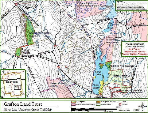
Printing instructionsThe maps print on letter-size paper. Print the trail maps using the Adobe |
|
![]()
- Anderson-Crosier Woods
- Brigham Hill Community Farm CR
- Brigham Hill Connector
- Brigham Hill Wildlife Area
- Fletcher Reserve
- Forbush Sanctuary
- Gebelein Sanctuary
- George Knowlton Preserve
- Gummere Wood
- Harris Wildlife Preserve
- Hazzard/Pond Preserve
- Lambert Property
- Marsters Preserve
- Mazza Farm CR
- Meranto Landing
- Nicholson Family Preserve
- Old Dawes Pond Preserve
- Parker Preserve
- Platt Preserve
- Potter Hill Meadows
- Prescott Wildlife Sanctuary
- Rita Martin Preserve
- Roger Hohman Sanctuary
- Salisbury Preserve
- Williams Preserve CR
- Williams Woods